
Bukhansan National Park 북한산국립공원
Summer Season (Apr-Oct) - 4:00 to 17:00
Winter Season (Nov-Mar) - 4:00 to 16:00
Hiking at night is prohibited
Free
3 of the popular entry points to Bukhansan National Park:
To reach the highest Baegundae Peak / Scenic valley & main road easy loop trail:
Gupabal Station 구파발역 (line 3, exit 1). U-turn upon exit. The bus stop is about 20m ahead. Take Bus 34/704/8772 and get off at Bukhansanseong (Fortress) 북한산성 (about 17 mins) bus stop. All of the stops are announced in English. After alighting the bus, walk in the same direction as the bus, turn right at the first junction and follow the road all the way to Bukhansanseong Park Information Center (park's entrance).


For an easy experience of the mountain national park
Gireum Station 길음역 (line 4, exit 3). Take Bus 110B or 143 and get off at the last stop (about 13 mins). Walk up the gentle slope until reaching the park entrance (10 mins). Jeongneung Park Information Center is located next to the park entrance.
Note: Search for 'Gileum' instead when using MetroidHD app.


Direct subway access to Dobongsan for Jaunbong Peak/Uiam Rock:
Dobongsan Station 도봉산역 (line 1/7, exit 1). Cross the road at the traffic light upon exit. Follow the local hikers to the park entrance. 20 mins. You would walk past many food stalls and hiking shops along the way.


💡Hiking is very popular with the Koreans. Come on the weekend and you can easily follow the colourfully-clothed Korean hikers on the trails. There are signs along the way too.
Bukhansan National Park in Guinness Book of World Records
With around five million visitors each year, Bukhansan National Park is listed in the Guinness Book of World Records as the 'Most Visited National Park per Unit Area'.
It is one of Korea's most popular hiking destinations and maybe the most beloved of Seoul's mountains.
There are different levels of hiking trails from Easy, Moderate, Intermediate, Advanced to Expert levels, suitable all hikers or leisure visitors on a day trip out in nature, right in Seoul city.


Ease of Access by Public Transport to Bukhansan National Park, Seoul
Bukhansan National Park has several entrances and is easily accessible by public transport (i.e bus/subway) from anywhere within the Seoul Metropolitan with relatively short travel time. e.g. within 30 mins to 1 hr from Myeongdong/Seoul Station.
Highest Peaks of Bukhansan National Park
Baegundae Peak, at 836.5m is the highest peak in Bukhansan National Park, followed by Insubong Peak at 810.5m and Mangnyeongdae Peak at 799.5m.


What to See at Bukhansan National Park
Bukhansan National Park has dozens of gorges and granite peaks with crystal clear streams flowing between them, creating a beautiful harmony of nature.
The national park is home to some 3,100 species of plants and animals, numerous historic relics and Buddhist temples.
From each entry point, there are multiple trails weaving along the mountain, making it a new experience hiking at Bukhansan National Park with different paths or seasons.


Hiking Care 🧸
Please wear comfortable shoes, bring bottles of water, optional snacks for your hike and buffer enough time for the return trip as well.
In winter, proper footwear is required to walk on the snow ice. You can consult with the hiking shops leading to the park entrance as they generally do sell affordable slip-on snow ice crampons for your shoes.
For overseas travellers, you can rent hiking gears (e.g. boots, clothes, crampons, trekking poles, gloves, backpack) at Seoul Hiking Tourism Center, 5 mins walk from Bukhansan Ui Station (Ui LRT, exit 2). Rental items are cleaned, washed, sterilized, and disinfected after every use. The center also provides hiking course guidance & information, Seoul Hiking Guide Book and maps.
Not often, however, if you come across any Korean only sign during your hike, you can use Google Translate app by pointing your phone at the Korean signage🤳 and use the camera feature on the app for instant language translation.


【Bukhansanseong Park Information Center】
Highlights: Trail leading to the popular highest Baegundae Peak / Relatively easy, scenic valley & main road loop trails starting from information center / Good number of decent hiking shops, cafes and restaurants near Bukhansanseong Park Information Center.
a) Around Bukhansanseong Park Information Center
Upon reaching Bukhansanseong Park Information Center, you can get a useful leaflet on Bukhansan National Park's trails map and information from the counter. You can also speak to the park's staff on their recommended trails based on your preferences, time available and fitness. Public toilet is located next to the information center.

After walking past Bukhansanseong Park Information Center, you will reach a forked road that leads to either the Valley Trail or Main Road Trail. Both Valley and Main Road trails merge at an intersection about 30 mins into the walk.


Map of Hiking Trails from Bukhansanseong Park Information Center

Map Aound Bukhansanseong Park Information Center

b) Starting Trails - Valley or Main Road (30-40 mins, 1-way)
Valley and Main Road trails merge at the intersection near Bukhansan History Museum. From here, hikers can continue on your onward advanced hike to Baegundae Peak.

▶ Scenic Valley Trail
The Valley Trail is a relatively easy trail with beautiful valley, stream and mountain views.
At the start of the trail is a lookout point of the four peaks of Bukhansan, namely, Wonhyobong Peak (505m), Mangyeongdae Terrace (799.5m), Baegundae Peak (836.5m) and Nojeokbong Peak (716m).
💡To stay on the course, do not cross the 2 bridges located at the start and towards the end of valley trail.


▶ Main Road
The Main Road nature trail which is used by authorised vehicles as well, offers a different hiking experience compared to Valley Trail.
You will walk past Muryangsa Temple and Daeseomun (Great West Gate) with stunning views of the mountain peaks and valley along the road.


In autumn, enjoy the different colourful shades of autumn foliage on this easy walking trail.


c) Main Intersection of Valley Trail and Main Road
At this main intersection, there are Bukhansan History Museum (+information center), rest area, public toilet and drinks vending machine.
From here, hikers can continue on your onward advanced hike to Baegundae Peak or head downhill back to Bukhansanseong Park Information Center via the Main Road or Valley Trail.


d) Bukhansanseong Course to reach Baegundae Peak
Bukhansanseong Course is one of the most popular hiking trails leading to the highest Baegundae Peak (836.5m). The one-way 3.4km course from Bukhansanseong Park Information Center to Baegundae Peak takes about 2 hrs 40 mins.
The real mountain trail starts from Borisa Temple after the main intersection at Bukhansan History Museum. The last part of the course is a steep incline that requires holding onto the ropes to reach the peak and be rewarded with breathtaking view.


e) Hiking Shops near Bukhansanseong Park Information Center


f) Cafes & Restaurants near Bukhansanseong Park Information Center


【Jeongneung Park Information Center】
Highlights: Easy to reach by public transport / Trail to Bogungmun (Gate) & Daeseongmum (Gate) / Good signage on directions, introduction to park's flora & fauna and history of places / Easy walking trail along the stream or take the Nature Interpretive Course / Spring water for drinking
a) Jeongneung Visitor Center (Dec-Feb: 10:00-17:00 / Mar-Nov: 9:30-17:00 / Lunch Hours 12:00 - 13:00 / Closed on Wednesdays)
Jeongneung Visitor Center is located in a nice small building with a museum and public toilet.
You can get a leaflet on Bukhansan route map and course recommendations from the staff.


b) Jeongneung Park Information Center
A short walk from Jeongneung Visiter Center and after passing a big public parking lot will bring you to Jeongneung Park Information Center and the entrance to Bukhansan National Park.


Map of Hiking Trails from Jeongneung Park Information Center

Zoom in Map from Jeongneung Park Information Center

c) Bogukmun (/Bogungmun) Course (1 hr 20 mins, 2.4km, 1-way)
Bogukmun Course is the most popular hiking trail in Jeongneung District, stretching from Jeongneung to Bogukmun (Gate).
From Bogukmun (Gate), you can do a loop course from Bogukmun (Gate), Daeseongmun (Gate), Yeongchuisa back to Jeongneung Park Information Center (total loop course: 6km, 3 hrs).
Clear streams, waterfall and naturally grown oak trees are some of the beautiful sights of this course.
d) Seasonal Highlights
▶ Summer


▶ Autumn


▶ Winter


e) Spring Water for Drinking & Nature Interpretive Trail (Easy Level)
For those looking for an easy and scenic hike, you can walk from Jeongneung Park Information Center towards Cheongsucheon (Pond) for its crystal clear spring water for drinking and take a break, surrounded in the beauty of nature. You may even come across locals bringing big bottles to fill up spring water!


After which, you can head back towards Jeongneung Park Information Center and enter the Nature Interpretive Trail. There are many informational signs introducing the flora along the trail as well.


Map of Nature Interpretive Trail

Signs to Nature Interpretive Trail


f) Restaurants near Jeongneung Park Information Center
After hiking, why not have an authentic (and affordable) Korean meal at one of the restaurants near to the park entrance?


【Dobong Park Information Center】
Highlights: Trails to Uiam (Rock) & Jaunbong (Peak) / Interesting rock formations along the trail / Limited or Korean signage further onto the trail / Temples / Great autumn foliage / Local vibes with numerous hiking shops, food stores & restaurants from Dobongsan Station to Dobong Park Information Center
a) Around Dobong Park Information Center
You can get a useful leaflet on Bukhansan National Park's trails map and course recommendations from Bukhansanseong Park Information Center.
Public toilet is a short distance away next to the restaurants.


Maps of Hiking Trails from Dobong Park Information Center


b) Hiking Trails from Dobong Park Information Center
Sinseondae Course (1 hr 40 mins, 3.3km, 1-way)
This is the main hiking trail from Dongong Park Information Center to Sinseondae and the three highest peaks of Dobongsan Mountain, namely Seoninbong Peak (708m), Manjangbong Peak (718m) and Jaunbong Peak (740m, no trail leading to peak).
In fact, besides the Sinseondae Course, there are many other scenic, interesting and easier trails from Dongong Park Information Center for your discovery.


c) Interesting Rock Formations along the Trail


d) Picnics by the Rocks


e) Temple, Temple....and more Temples


f) Food Stores & Restaurants from across Dobongsan Station to Dobong Park Information Center


g) Hiking Shops near Dobong Park Information Center


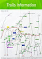
Map of Hiking Trails at Bukhansan National Park

Bukhansan National Park - Leaflet from Bukhansanseong & Jeongneung Park Information Centers (with highlights on popular courses)


Bukhansan National Park - Leaflet from Dobong Park Information Center (with highlights on popular courses)

KoreaToDo TOP PICKS - Tours, Activities & Discount Tickets
➥ Handpicked experiences by KoreaToDo for their uniqueness, value, popularity, price competitiveness and at times, tedious to reach by public transport.


♔ KoreaToDo recommends Klook.com, Asia leading in-destination service provider.

🥁 SEASONAL HOT PICKS🥁 Handpicked Experiences from Seoul


Other KoreaToDo outdoor activities collection (outside Seoul) that you may like:
KoreaToDo outdoor activities collection (within Seoul) that you may like:
-
Gwanaksan Mountain (629m) - Diverse hiking courses from forest valley to exposed rocks terrain
-
Inwangsan Mountain (338.2m) - Hiking trail alongside Seoul City Wall on the mountain ridges
Still looking? Explore KoreaToDo handpicked collection of: